Converting AMG66/AMG84 coordinates to MGA using Trimble Terramodel
Step 1. Import Latitude, Longitude & Height points data into Terramodel. If the data is already in Terramodel, skip straight to Step 5.
From the main menu, select File / Download Import / ASCII pts
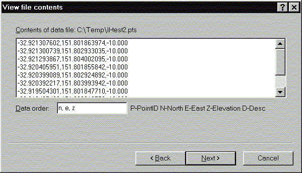
Step 2.Select a PTS or data file
Step 3. Change the data order to n,e,z if the file has Latitude, Longitude, Height as below.
Note: Latitude, Longitude must be in decimal degrees (DDD.dddddd)
Step 6. Click the [Coordinate systems] button
Step 7. Change the From system to LL-360 as above. This is a generic format for Latitudes and Longitudes in decimal degrees. Longitudes are east values only in the range 0 to 360 degrees.
In this example we will assume the Lats/Longs are on the AGD66 defined spheroid and the required Coordinate System is AMG66 ZONE 55.
Step 8. Change the To system to AMG66 Zone 66 as above, then click the [Ok] button.
Note: If the Coordinate System has not been defined, see Creating a new Coordinate System in Terramodel.
Coordinate Conversion Report
Input CS: Generic Lat/Long’s, Degrees, 0 ==> +360
Output CS: AMG66 ZONE 55 WRT GDA94
Input Units Assumed: DEGREE
Output Units Assumed: METER
Point Latitude Longitude North East
1 -32 03’10.2339″ 145 44’22.0964″ ==>> 6453000.0000 381000.0000
2 -32 03’15.2227″ 145 44’10.0138″ ==>> 6452842.6730 380684.9260
3 -32 03’15.2227″ 145 44’10.0138″ ==>> 6452842.6730 380684.9260
4 -32 03’15.2358″ 145 44’10.0308″ ==>> 6452842.2730 380685.3780
5 -32 03’15.2460″ 145 44’10.0438″ ==>> 6452841.9650 380685.7220
6 -32 03’15.2889″ 145 44’10.0992″ ==>> 6452840.6610 380687.1890
: