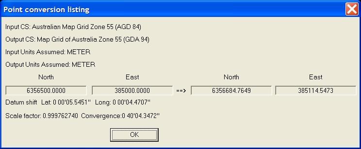
If the transformation uses an NTV2 GSB shift file, check that the Datum Shift value for Lats and Lons are displayed. This indicates that the NTV2 GSB coordinate shift file is being used to transform from the AGD84 datum to the GDA94 datum.
If a Datum Shift value is not displayed it could indicate that the point is outside of the areas covered by the GSB file or there is a problem with the configuration of the data files. When a point falls outside of the areas covered by a designated GSB file, the datum conversion resorts to the 7-parameter datum transformation fall-back entered in the GDC file for the projection.
For this particular transformation (AGD84 to GDA94), the relevant GDC file is: C:\Program Files\Trimble\Shared\Mentor.dir\Agd84ToGda94.gdc. For Terramodel 10.40 with Geocomp Update, Agd84ToGda94.gdc points to C:\Program Files\Trimble\Shared\Mentor.dir\GridData\Australia\AGD84_national.gsb.
Step 11. If you now wish to proceed with converting single or multiple points (or other XY objects), select the [Multiple points] button.
Step 12. Select all the XY objects to be converted.
Step 13. Click the [List] button to produce a printable listing of the coordinate conversions if required.
Coordinate Conversion Report
Input CS: Australian Map Grid Zone 55 (AGD 84)
Output CS: Map Grid of Australia Zone 55 (GDA 94)
Input Units Assumed: METER
Output Units Assumed: METER
      North        East             North        East
572 6356190.7177 385089.6448 ==>> 6356375.4828 385204.1917
573 6356190.8613 385091.2580 ==>> 6356375.6264 385205.8048
575 6356179.8178 385194.5951 ==>> 6356364.5828 385309.1418
576 6356185.9546 385200.5033 ==>> 6356370.7195 385315.0500
577 6356171.4471 385193.4751 ==>> 6356356.2121 385308.0218
Step 14. Click the [Convert] button to convert the selected objects within Terramodel.
Note: GCCOORD ignores point heights. A point height of 0.0 is assumed for the 3D transformation, and the existing point height is then assigned to the transformed point.